
- Anacortes Parks and Site Map
- Washington Park
- Ship Harbor Interpretive Preserve
- Volunteer Park - Kiwanis Meadows Park - Daniels Field
- John Storvik Playground Park
- Deception Pass State Park
- Anacortes Forest Lands
- Mount Erie Park
- Causland Park
- Rotary Park Disc Gold Course, Rotary Park and Cap Sante Park
- Sharpe Parks and Montgomery - Duban Headlands Parks
- Alice Parchman Newland Park
- Ben Root Skateboard Park
- More Parks and Playgrounds
Washington Park
Location : 6300 Sunset Avenue – the West end of Anacortes at Sunset Beach
This site is located at the very west end of the city on Rosario Strait and contains a wide variety of facilities. The site is divided into two basic parts: a day use area consisting of a boat launch, picnic shelters, restrooms, children’s play equipment and open play area. Overnight camping area consisting of 68 campsites for RVs and tents, with restrooms, showers and laundry facilities. Only about 41 of the 200 acres are developed but a 2.3 mile paved road runs through the entire park for use by cars, joggers, bicyclists and walkers. For information about any park amenities, please call 360-293-1918.
Ship Harbor Interpretive Preserve
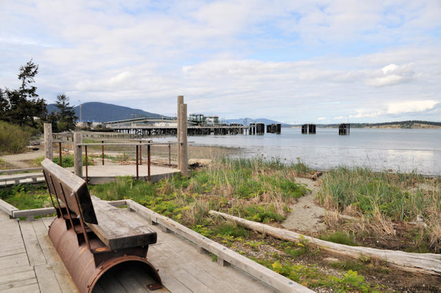 SHIP is located between the Washington State Ferry terminal on the west, and residential developments near the cul de sac at Edwards Way on the east. There is a trail system that is protective of particularly sensitive areas and also provides environmental education about the role and significance of the beach and wetlands. In addition to the 25 acres of freshwater wetlands, there are also five acres of upland habitat and 2,000 fee of sandy beach and subtidal eelgrass beds. It is a rich and interesting area, with an abundance of plants and wildlife – such as great blue herons; wrens and sparrows; small mammals; Dungeness crabs; and hawks and sea gulls. There is also a 1,000 foot long, 6 foot wide pedestrian boardwalk, built to be an extension of the 1,600-foot path from the Edwards Way cul-de-sac west of San Juan Passage to the wetlands.
Volunteer Park – Kiwanis Meadows Park – Daniels Field
Location : 1915 13th Street at 14th St. and H Ave.
This still developing sports field complex has been largely a volunteer effort with the Anacortes School District and City of Anacortes. There are approximately 24 acres of developable space, 15 acres of which are leased from the school district and are developed with three baseball fields and a soccer field. The Kiwanis Meadows area is a full size soccer field / open space that is lined with trees to create a meadow like feeling.
The Marguerite and Don Daniels field is an artificial turf field, and the Alton R. Daniels and Volunteer fields are regulation baseball fields. There are 45 acres of wet lands and open space and a 9 acre developing area called the Rice Complex that when completed will contain a football/soccer stadium, 400 meter surfaced track and associated amenities. The newest addition is the Doug Colglazier Playground that includes play equipment, a covered picnic shelter and a full-sized basketball court.
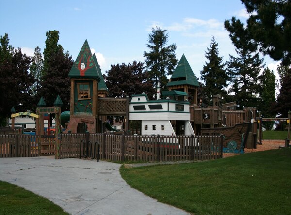
John Storvik Playground Park
 Location : 1110 32nd Street between 29th St. and 32nd St.
John Storvik Park is well designed and contains a little league game field (which also serves as a youth soccer field), restrooms, children’s play area, two basketball courts, picnic area and parking. If you’d like to reserve the covered picnic area, call 293-1918 for availability.
Deception Pass State Park
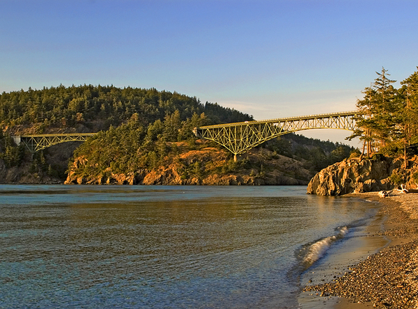
A 4,134 acre marine and camping park with 77,000 feet of saltwater shoreline and 33,900 feet of freshwater shoreline on three different lakes. Breathtaking views, old growth forests, and abundant wildlife can be seen all over the park.
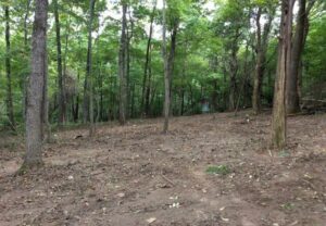
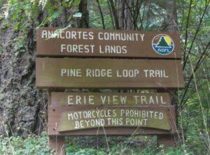
Anacortes Forest Lands
The City of Anacortes owns 2,800 acres of forest lands called the Anacortes Community Forest Lands (ACFL) in several large tracts. The forest lands are within the city limits and include forested hills, lakes, streams, wetlands and meadows. Twenty miles of trails provide public access to the forest lands. There are nine loop trails designed for horses, motorcycles, bikes and hikers. Some areas are restricted to specific user groups. The terrain varies and trail side viewpoints provide territorial views. Trail maps are available at various businesses around town.
Mount Erie Park
Location : Ray Auld Drive and Heart Lake Road – South of Anacortes, off Heart Lake Road
Mt. Erie is a 160 acre Park. At the top of Mt. Erie, elevation 1,270 ft, choose from four viewing areas and be rewarded with spectacular views in every direction. Mt. Erie is, the highest point of Fidalgo Island and is part of the former Anacortes watershed. There is a small parking area and a road to the top of Mt. Erie. Trails from this area lead into a portion of the 1400 plus acres of the Anacortes Forest Lands.
Causland Park
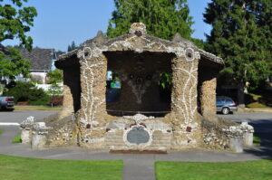
Location : 710 N Avenue at 3rd St. between M and N Ave.
Built in the 1920’s by John Baptiste LePage to honor Anacortes veterans from World War I to the Vietnam War, this is a unique park with extensive ornate rock work in downtown Anacortes – and is on the National Register of Historic Places. Low, serpentine mosaic walls surround the park, and a bandstand, amphitheater and terraces are similarly made of colored pebble and rock mosaic. Other park features include picnic tables, mature ornamental plantings, a small grassy lawn and many terraces.
Rotary Park Disc Gold Course, Rotary Park and Cap Sante Park
 ROTARY PARK DISC GOLF COURSE
Location : 701 T Ave Anacortes WA
The city has a nine-hole disc golf course at Rotary Park. For a course map CLICK HERE. The disc golf course was made possible with support from the Anacortes Parks Foundation, the City of Anacortes, and the Rotary Club. Please be mindful of other park users, pack-out all of your trash, and respect the neighboring residences. The course is a challenging short par-3 course with many obstacles. Since this is a new course we will have some upcoming work parties to help “groom” the fairways.
 ROTARY PARK
Location : 701 T Avenue at 6th St. and T Ave
Rotary Park is a 1.5 acre linear park located on the north and east edge of the Cap Sante Boat Haven at the base of Cap Sante. Rotary Park has a paved pedestrian trail out to the Cap Sante breakwater, picnic tables and a shelter. Parking is available at the start of the trail.
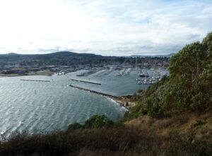 CAP SANTE PARK
Location : 1000 W Avenue at 4th St. along W Ave.
Primarily a vista point, this 37 acre forested promontory affords an excellent view of the the marina, the City of Anacortes, March Point, Fidalgo Bay, Mt Baker and the Cascades.
SHARPE PARK & MONTGOMERY-DUBAN HEADLANDS PARK
Location : 14692 Rosario Road Anacortes WA
A 110-acre Skagit County Park with the largest remaining undeveloped waterfront on Fidalgo Island near Anacortes. Highlights include a freshwater beaver pond and the stunning views of Rosario Strait. A short 3/4-mile walk through old growth firs, madronas, and lichen- shrouded trees takes you to sweeping views of north Puget Sound. Kids will enjoy walking first along the trail by a large pond filled with widgeons, mallards, cattails, and red-winged blackbirds.
Alice Parchman Newland Park
Location : R Avenue between 32nd and 22nd Streets
A 10 acre linear park and street median developed along the R Avenue access road from Highway 20 into Anacortes waterfront industries and recreation areas. The south end contains the Smith sculpture, and the north end of the median widens to accommodate the Ben Root Skate Park. There is a view of Fidalgo Bay.
Ben Root Skateboard Park
Location : 2313 R Avenue at 23rd St. and R Ave.
The Ben Root Skate Park is located within Alice Parchman Newland Park and offers a view of Fidalgo Bay. Adjacent to the park is a trailhead for the Tommy Thompson Parkway. The 7,500 square foot concrete skate park has parking, drinking fountain, lights, seating and a restroom nearby.
More Parks and Playgrounds
 CRANBERRY LAKE AREA
(off Georgia Ave at Cranberry lake Road)
This site, found near the city center, is heavily forested and contains Cranberry Lake (approximately 27 acres) and several other small lakes and bogs. The site varies in terrain from flat to steep slopes. An extensive trail system is found in this area.
KEITH SHUGARTS PLAYGROUND
(10th Street and N Avenue)
After you’ve chosen your books, enjoy a .5 acre playground with picnic tables and playground equipment on the City of Anacortes Library site.
CLEARIDGE PARK
(1900 Block of Blakely)
This is a .8 acre partially developed recreational area of two tennis courts and basketball court, near the Anacortes Airport. It was given to the City as part of the subdivision process as homes were developed in the west side of Anacortes.
MT. ERIE SCHOOL CITY PLAYGROUND
(at 41st St. and M Ave.)
This is a park site located on the school grounds and is a joint development with Anacortes School District and City of Anacortes.
SEAFARERS MEMORIAL PARK
(at 14th St. and Seafarers Way)
Site of the Seaman Memorial at the Cap Sante Marina. Parking, picnic tables, promenade and beach access with a beautiful view of Fidalgo Bay.
ALTAIR-AMERICUS MEMORIAL PARK
(between 7th St. and 9th St. on R Ave.)
Next to the Steam wheeler W.T. Preston, stands the memorial to “The A Boats”.
KIWANIS WATERFRONT PARK
(1708 6th Street)
2 acres of developed parkland located on the north Anacortes shoreline. There are picnic tables, benches, pathways, overlook, beach access and parking to help enjoy the views of the Guemes Channel, Guemes Island, boat traffic and ferry traffic.
ACE OF HEARTS ROTARY PARK
(38th St. & H Avenue)
The fenced dog areas include off leash dog areas, one for large dogs and one for small dogs; plus water for the pets, pet waste disposal bags and portable restrooms. The City of Anacortes Parks Department, Anacortes Rotary Club and the Anacortes Little League worked together to develop a new baseball field. Ace of Hearts Rotary Park also includes wetland improvements, parking lot, trails, and a creek. Dogs must have current vaccinations and a license.
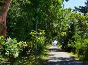
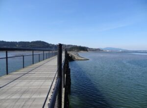 TOMMY THOMPSON PARKWAY
(Trail heads at 22nd Street and R Avenue, Fidalgo Bay R.V. Park and 30th & U Ave.)
There are approximately 3.3 miles of paved trail for pedestrians and bicyclists between 11th Street and across the train trestle to March Point Road. A breakdown of the mileage is 11th St. to 22nd St. is 0.6 miles, 22nd St. to 34th St. is 0.7 miles, 34th St. to RV Park is 1.0 miles, RV Park to trestle is 0.6 miles and across the trestle is 0.4 miles for a total of 3.3 miles.
JOHN AND DORIS TURSI PARK
(2200 Pennsylvania Avenue)
A newly developed neighborhood park with play equipment, a zip line and picnic tables.
28th STREET PLAYGROUND
(28th Street and Q Avenue)
A half-acre playground on “Q” Avenue. There is children’s play equipment on the site.
ROADSIDE PARK
(Jackson Avenue and Oakes Avenue)
A 0.3 acre street end with views of Guemes Channel.
N AVENUE PARK
(2nd Street and N Avenue)
0.4 acres of undeveloped street-end park land with views to Guemes channel